Projects
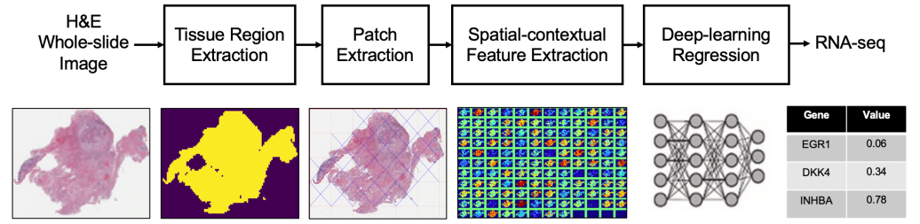 |
RNA-seq prediction from histopathology images • Proposed an AI method to predict RNA-sequence directly from histopathology images to save genomic testing time and cost. • Integrated a neural image compressor to preserve spatial-contextual information in whole-slide image with a deep-learning regressor to predict RNA-seq. • Achieved 4.12% higher mean correlation and predicted 6 out of 10 genes with better correlation than a state-of-the-art baseline method on TCGA-HNSC dataset. [Paper] |
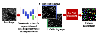 |
Blur-robust Nuclei Segmentation • Analyzed the performance of nuclei segmentation algorithms on out-of-focus images for different blur levels. • Proposed a deep learning encoder-decoder framework with a novel Y forked decoder to learn two tasks simultaneously - segmentation and deblurring. • The addition of a separate deblurring task in the training paradigm helps to regularize the network on blurry images which improves nuclei segmentation on sharp as well as out-of-focus images. [Paper] |
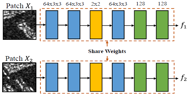 |
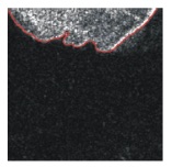
Small Object Change Detection in SAR Images • Developed a Siamese Convolutional Neural Network to detect changes in a parking lot using multi-temporal synthetic aperture radar(SAR) images of Earth. • Applied contrastive loss function for optimization, achieving 15% higher f-measure. •Developed a multitask learning framework to robustly detect subtle changes in SAR images. [Paper] |
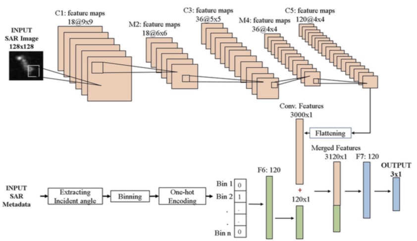 |
Ship Classification for Maritime Surveillance of SEZ's • Invented a Convolutional Neural Network-based ship classification method that incorporates image metadata. • Created useful features from image metadata using one-hot-encoding for training the network. • Achieved 11% improvement in classification accuracy of 3 ship types over a hand-crafted feature-based baseline and 25% reduction in training data requirement. [Paper][PPT] |
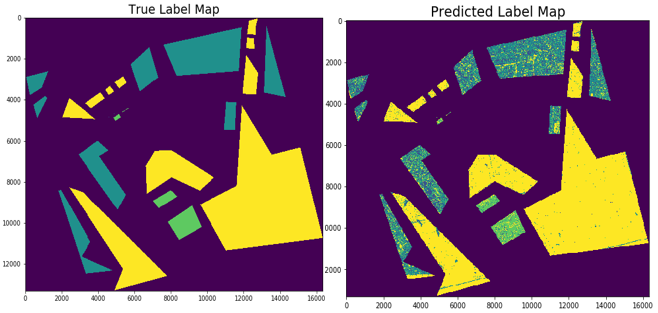 |
Land-use Land-cover Segmentation • Created an application to segment 5 types of land cover from satellite images over Japan. • Proposed new methods of data exploration and evaluated class imbalancing effect. • Presented results to business division, increasing both research budget and speed by 3x. |
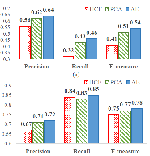 |
Comparative Study of Feature Extraction Methods in Moderate Resolution Satellite Images • Surveyed 50+ research papers in 2 weeks on feature extraction in satellite images. • Developed first comparative study on the feature extraction approaches including hand-crafted features, Principal Component Analysis (PCA) and Autoencoder. • Demonstrated a case study on ship classification with challenging cases of small length and fast ships in an international conference IGARSS 2018. [Paper][Poster] |
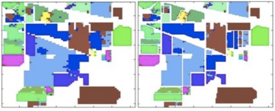 |
Hyperspectral Image Super-resolution • Developed a super-resolution technique to improve classification of mixed pixels in hyper-spectral images. • Applied Ant Colony Optimization to seperate spectral features of different classes within each mixed pixel. • Enhanced classification accuracy by 21% over baseline and obtained visually high-resolution classified maps. [Paper] |
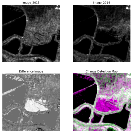 |
Unsupervised Change Detection using Deep Learning • Implemented unsupervised change detection for multitemporal images employing Sparse Autoencoder for feature extraction, Fuzzy C-Means for clustering and CNN for classification, achieving 98% accuracy. |
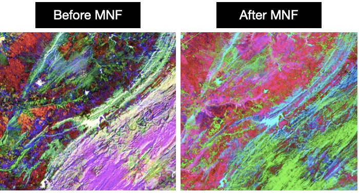 |
Dimensionality Reduction of Hyperspectral Images • Executed Minimum Noise Fraction (MNF) algorithm for optimal feature extraction and noise decorrelation in hyperspectral images. |
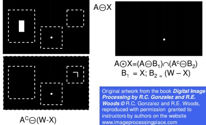 |
Shape detection using Hit and Miss Transform • Implemented a Pattern Recognition Technique for detecting geometrical shapes in an image. • Created Graphical User Interface using MATLAB GUI for displaying and counting the desired shape. |
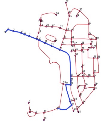 |
Optimal Bike Path Development and Shortest Route Detection • Developed a digital road map of IIT Bombay with important stops and frequently travelled paths in QGIS. • Implemented Dijkstra Algorithm to find shortest route between two stations by running a query. |
 |
Feature Extraction Using Active Contour Models • Reviewed various feature extraction techniques for colour, texture and shape-based features in an image. • Implemented Snakes Algorithm in MATLAB for road and coastline detection in satellite images. |